


Exploring Hiking Trails in Taiwan
A small town on the coast of Northern Taiwan, Keelung is perfectly located – only half an hour from Taipei, but close to a variety of hiking trails exploring both the wild jungles and peaceful coastlines of Taiwan. Though Keelung is known for its rainy weather, during my stay there I was lucky to experience several days of sunshine which I spent exploring the trails close to the city.
Without further ado, here are my favourite ones:
1. Keelung sign to lighthouse
- Difficulty level: easy
- Duration: 3-4 hours
- Total distance: 11.3 km
- Transportation options: Once you reach the lighthouse, you can take bus 301 from Taibaizhuang bus stop back to Maritime plaza.

This first trail connects the two quintessential landmarks of Keelung: Keelung sign and Keelung lighthouse. There are several little paths you can wander off to along the way and easily come back to the main trail. Google Maps doesn’t have some of the smaller paths, but I’ve marked the changes with red, and any optional routes with yellow. There are also a couple of spots where you have to walk along a quite traffic heavy road, but I’ve tried to keep those to the minimum. The whole hike should take you about three to four hours, so let’s get going!
Maritime Plaza to Huzishan Keelung Landmark
We start the trail at the Maritime Plaza and head for the Keelung sign (Huzishan Keelung Landmark on the map). This part of the trail is fairly straightforward: just go to the bus station, cross the road and start climbing up the little streets. Feel free to go exploring in this area since most of the paths lead back to the main road that takes you up to the sign anyway. See if you can find this little art gallery for example.


Huzishan Keelung Landmark to Zhonghua Road

Once you reach the Keelung sign, take a moment to enjoy the view, then head for the stairs behind the sign that goes up the mountain. After a while you’ll see the small set of stairs on your left (see middle photo). There you can take your first detour to see the city view from Noon-Day Gun Ruins.


 Alternatively, you can skip this step and keep following the main path. Either way, you’ll end up on a bigger road and see a sign pointing you to Daeda Mountain Trail. This is the small detour path marked in red on the map. The path starts behind this cute temple you can see in the photo.
There are some nice views, but again, feel free to skip this step and just follow the main road. After Daeda you’ll be back on the road and see a sign that says Grand Hike Trail. Follow that for the rest of the first half of the trail.


Zhonghua Road to Baimiweng Fort and Keelung Lighthouse
Once you get down to Zhonghua Road, the first annoying bit comes and you’ll have to walk along a big road for a couple of minutes. Once you reach a gas station below the expressway (see photo on the left), turn right behind it and keep walking until you reach this road with a gate.


 Google seems to think that this is the road to Baimiweng Fort when you clearly can’t go there. But don’t worry, there’s another trail behind it. So keep walking until you see some apartment buildings. Before the buildings, there’s a set of stairs to your left (see photos below). Go up those stairs and then you can follow that same road that’s closed off.


Following that road, you’ll get to Baimiweng Fort. Take a moment to soak up the history and enjoy the beautiful views of the sea, and then head for the stairs behind the red gazebo. Though this path doesn’t show up on Google Map, it is clearly marked and definitely the more picturesque trail to the lighthouse.


Congratulations! You’ve reached Keelung Lighthouse. From there, it’s time to freestyle. Go check out the Buddha Hand Cave and Fairy Cave nearby, or watch the container cranes work in the harbour. Or if you’re tired, just take bus 301 back to Maritime Plaza.

2. Nanrong Cemetery
- Difficulty level: easy
- Duration: 2 hours
- Total distance: 6.8 km
- Transportation options: Once you reach the cemetery, you can take bus 787 from Nanrong Cemetery bus stop back to Chenghuang temple close to Maritime Plaza.

Living on Ai 9th Road in Keelung, I’m lucky to have a beautiful mountain full of hiking trails right behind my house. This one was introduced to me by a fellow workationer and it’s become one of my favourites. It’s not too long, only two hours, and has everything you could wish for: an observatory tower, an abandoned jungle gym, a temple, a cave, and a cemetery! So hop into those hiking boots and let’s go!
River to Rotary Tower
We’ll start by the river, at the intersection of Renyi and Liu Ming Chuan Road. Go up the road towards the mountain until you reach the stairs to the Junior High School (left photo). Go up the stairs, follow them to the left until you get to a road again. Across the road you’ll see the beginning of the mountain trail (right photo).


 After climbing those stairs, you get to a crossroads of paths and stairs. Take the stairs on your right that go underneath a small arch. This first half of the hike is a nice workout for the legs – the stairs keep going for quite some time but you’ll be rewarded with stunning views from the top. Once you reach the top of the stairs, you’ll see a sign that points you to the Rotary Tower – our first landmark. You’ll see the top of the tower way before you actually reach it, so it’s easy to follow.


Rotary Tower to Buddha’s Light Cave
After enjoying the views from the tower, don’t go back the same way, but follow the path until it meets another one. From there follow the sign that points you towards Xiaxitou Mountain Villa. Once you get to a crossroads, take the path on your left that points you to Renyou Mountain Villa (see photo). This path doesn’t show up on Google Maps, but I’ve marked it with red on the map.


 You’ll go down that path for a while, all the way until you reach a bigger road with a temple on your right. On your way you’ll see a fun jungle gym, so feel free to play around there for a bit!
Once you get to the road, turn left and almost immediately you’ll see a sign for the Buddha Light Cave across the road that points you down a set of stairs. This is probably my favourite part of the trail as you get to walk along the little creek surrounded by lush vegetation. When you get to the cave, go in and through it.


Buddha’s Light Cave to Nanrong cemetery
Coming out of the cave, you’ll see a cluster of houses with another temple on your right (and some cute dogs on your left!). On the crossroads, take the road to your left that goes slightly up. Following that, you get to our destination – the cemetery! The cemetery is very impressive, so feel free to explore around (respectfully of course).


If you’re tired, you can walk down to Nanrong Cemetery bus stop and take bus 787 back to Keelung city centre. Alternatively, follow the road through the cemetery and turn left at the top of the road to circle back to Hongdan mountain and down to Keelung along the same path you came up.


3. Houtong Cat Village to Jiufen Old Street
- Difficulty level: intermediate
- Duration: 2 hours for the hike + 2-3 hours for exploring the two locations
- Total distance: 6 km
- Transportation options: local train from Keelung station to Badu station (50 minutes), bus 788 from Jiufen Old Street back to Keelung bus station (52 minutes)

Jiufen Old Street is one of the most popular tourist destinations near Keelung, and for a good reason: the small town boasts a huge variety of shops and street vendors lined along the crooked historical street that looks like something straight out of a fairytale. As the night falls, the hundred lanterns around the town light up, transporting visitors straight into Spirited Away. In fact, Jiufen is one of the places often cited as the inspiration behind Miyazaki’s movie.
Not far from Jiufen lies another popular tourist spot: Houtong Cat Village. Once a rich mining town, Houtong is now a haven for abandoned cats. The locals take care of the large population of felines, who in turn attract groups of tourists boosting the town’s economy. Cute cat-themed cafes and shops are scattered throughout the town, as of course are the cats, most of whom are used to humans and walk freely around the town requesting the visitors for pats and cuddles, or just enjoying a lazy day in the sun.
Although those two towns are both popular among visitors to Taiwan, most people don’t know that there is actually a beautiful hiking trail connecting them, making this a perfect destination for a relaxing full day hike. The trail is not very demanding and you can take it slow, enjoying the scenery around you. The first half is up a mountainside but nothing too steep, and the second half takes you downhill to Jiufen.
Keelung to Houtong Cat Village
I recommend starting before noon by taking the local train from Keelung station to Badu, and from there switching to a train to Houtong. The journey takes about 50 minutes and costs NT$35. In Houtong, take an hour or two to pet the cats, enjoy lunch in one of the cafes, and maybe get some cute cat-themed souvenirs.


Houtong Cat Village to Dacukeng Historical Trail

 From the cat village head for the Dacukeng Historical Trail by walking along Keelung River until you pass a cemetery and cross a stream, after which turn immediately right. Walk along this stream (see photo on right) until you come to a cluster of houses, and you have reached the trailhead for Dacukeng Historical Trail on your left. The trail is mostly uphill, but follows a beautiful clear mountain stream that’s perfect for cooling your feet as you work up a sweat.
Dacukeng Historical Trail to Hsiaojingua Outcrop
As you climb higher, you reach the ruins of Dacukeng Dashan Elementary School, a ghostly skeleton of a building. From there find the sign pointing you to the Dacukeng Stairway to Heaven. You should be able to see it at this point. Once you reach the stairs, you simply climb up and then you’re on the road.


Once you’re on the road, turn left and keep walking until you reach Ruishuan Road. From there, take another left and head for the Hsiaojingua Outcrop to enjoy some gorgeous views of the surrounding area: mountain on one side and clear blue ocean on the other. On top of Outcrop you should also be able to see your destination Jiufen.


Hsiaojingua Outcrop to Jiufen

To get to Jiufen follow the path along the mountain down towards Chin Hsien Junior High School. Once you reach the main road, I recommend not taking the first road that leads to Jiufen, but the one after that which goes through the cemetery. If you’re not familiar with Taiwan’s cemeteries, it’s a beautiful sight to behold, a small town all on its own.

As you walk down through the cemetery, explore the small side streets of Jiufen until you reach Old Street – just in time for dinner. Treat yourself to some stinky tofu and Grandma Lai’s Sweet Taro Balls as you watch the lanterns light up, painting the town in a rich glow of red and gold.


4. Xiaozishan Trail in Pingxi
- Difficulty level: intermediate
- Duration: 2-3 hours
- Total distance: 2-3 km but a lot of climbing
- Transportation options: Take bus F825 from No. 31 Bridge near Keelung station to Pingxi (43 minutes and it’s free!). Alternatively, take the local train from Keelung station to Badu and change for another local train to Pingxi station (1 hour 30 minutes, NT$58).
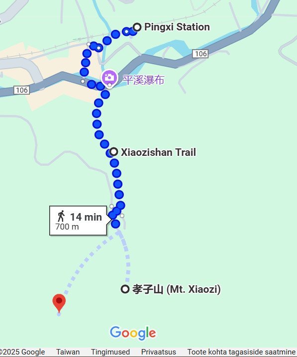
A small town barely an hour from Keelung, Pingxi is known for its lantern festival at the end of the Lunar New Year, but today I want to introduce you to another, more adventurous side of Pingxi: the Xiaozishan trail. This trail is fairly straightforward but offers a lot of fun. You won’t go far, but there’s a lot of climbing and you’ll go pretty high up the rocks, so if you’re afraid of heights you might want to skip this trail. But if not, then get ready to have some fun!
Pingxi station to Xiaozishan Trail
If you come to Pingxi by train, walk through the Old Street and across the river so that you’re on Jing’an Road (106 on map). If you take the bus, you’ll get off at Jing’an Road, so start walking to your right and you’ll see the trailhead with a map on the other side of the road.

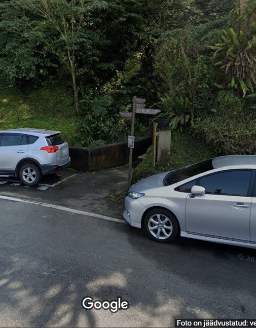
Exploring Xiaozishan Trail: Xiao Zi mountain
Start walking along the trail up the mountain until you get to a crossroads on a landing. There are three trails going out from there, one of which was closed on the day I went. I explored the other two which both took me about 30 minutes and they both circle back to this spot, so you can start with either one. For now, let’s take the trail to your left (Xiao Zi mountain) that goes up some steep steps.

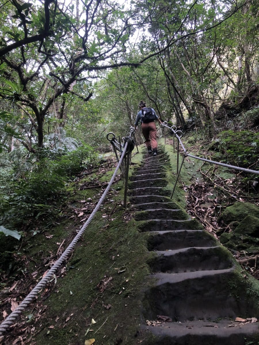

Go up those steps and you get to another landing. The trail continues up another rock on your left. You can see two paths there, but they’re both part of the same trail, so whichever one you choose, you’ll end up coming down the other one. There’s a lot of climbing along a fairly steep rock edge, so be careful. But the views from the top are magnificent!


Exploring Xiaozishan Trail: Ci Mu Peak
Once you are finished exploring Xiao Zi Mountain, come back down to the crossroads and take the path across the landing towards Ci Mu Peak (the sign will point in the right direction). This one starts with an even longer set of stairs carved into a rock, but it’s all worth it once you get to the top.


From the top of the peak you can continue down and do a circular path around the peak. The path is very steep and runs along the cliff’s edge so be careful and take your time. The path itself is very straightforward, so it’s impossible to get lost. Just follow the path and it will bring you back to the top of the peak. At the very last bit you’ll have to climb up a rockwall, but there’s a sturdy rope hanging there for you, so pull yourself up with the help of the rope and keep going!


At the top of Ci Mu Peak, make your way down again the same way you came up and go all the way down back to Pingxi. That’s it! Have a nice dinner at Pingxi Old Street and watch the lanterns drift up towards the sky, before you can take the bus or train back to Keelung.
5. Lovers Lake and Waimushan Coastal Boulevard
- Difficulty level: easy
- Duration: 3 hours
- Total distance: 8.9 km (5.7 km if you take the bus back)
- Transportation options: To get to Lovers Lake, take bus 509 from Keelung Bus Station to Qing Ren Lake. At the end of the trail, if you don’t want to walk all the way back to Keelung, you can take bus 302 from Xiehe Village to Keelung Old Station.

Lovers Lake is a popular tourist spot near Keelung and great for a relaxing break from the city. You can read more about the lake and the surrounding trails here and here, but today I want to take you for a hike combining Lovers Lake with a beautiful walk along the coastline.
Keelung to Lovers Lake
Getting to Lovers Lake is very easy as there are several buses running throughout the day. The most convenient option is to take bus 509 all the way to the lake. This particular bus leaves only a couple of times a day though, so make sure you check the times before you leave your house. Once you get to Lovers Lake Park, you’ll see signs pointing you to the lake and the circular path around it, as well as the smaller mountain paths, so feel free to explore around.


Lovers Lake to Dawulun Beach

When you’ve seen enough of the lake, head for the mountain trail that goes to Eagle Rock and Lovers Tower. You’ll see some amazing views of Dawulun Beach and the East China Sea from there. From Lovers Tower, take the trail that turns left and go down the mountain to Dawulun Beach.


Waimushan Coastal Boulevard
From Dawulun Beach turn right and walk along the seaside towards Waimushan Fishing Harbour. It’s a couple kilometre walk with a nice wide pedestrian walkway – perfect to enjoy the views of the sea on your left and the towering mountains on your right.


Waimushan Fishing Harbour to Keelung
 From Waimushan Fishing Harbour, walk through the little winding streets to Xiehe Village bus stop. There you can either take bus 302 back to Keelung Old Station, or walk. The walk back follows a busy car road, but the pedestrian walkway is pretty wide and well marked, so it’s a lovely walk back.


Leave a Reply